

Saturday 7th July 2018
Roe Valley Country Park – 7 miles
After a week of warm weather we decided to opt for a cool riverside walk at the Roe Valley Country Park, just outside Limavady. The River Roe is a fast flowing salmon & trout river and derives it’s name from the Irish Ruadh, meaning red, due to the peat stained colour of the river.

We set off from the Visitors Centre along the west bank of the river towards the Carrick Rocks Church, at the southern boundary of the park. Within a short time we spotted one of the old Bleach Green Watchtowers reminiscent of the thriving linen industry in the county between the 17th and 19th centuries. In fact Limavady became the most important weaving town in the county during this time.

Linen production was a very labour intensive activity and there are remnants of the various stages dotted throughout the Country Park. Flax would have been grown & harvested locally by farmers, as the soil & climate were ideal for growing flax. However this was back breaking work as the flax had to be pulled out by the roots and then dried in stooks!

The flax was then thrown into ditches of water to rot the stalks (the retting process) before being broken & crushed to break the flax stems (the scutching process). The threads produced by this process would then have been spun & weaved into linen fabric before finally being laid out on bleaching greens to be bleached by the sunlight. All in all, you can appreciate why linen was such an expensive fabric and why cheaper imports of cotton sadly signalled the demise of this industry in Northern Ireland.

We continued on our way passing a couple of weirs, but due to the unusual dry spell we’re currently experiencing there wasn’t any sign of water flowing.

In fact at Carrick Mills the old ford had almost dried up due to the lack of rain exposing the cobbled crossing.

[From here you can cross the footbridge and head back to the visitors centre]
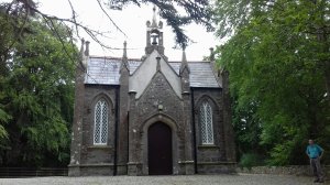
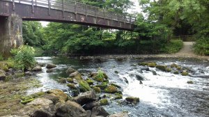
We opted to continue on the west bank to the Carrick Rocks car park. From here we climbed down steep steps to an old metal inverted bowstring bridge which is thought to date from 1900 and would have been used by locals to get to church . After a safe crossing we had a set of steep steps to climb to reach the church, and appreciated how fit our ancestors must have been! We took the opportunity to have a welcome rest in the church grounds before descending to the riverside!
[This part of the walk is outside the Country Park boundaries and care is required as you descend back to the river – good footwear is definitely recommended]
As we headed back towards the visitors centre on the east bank we met plenty of dog walkers and their dogs having fun in the water!

Shortly after the footbridge we passed the remains of the impressive Scutch Mill from the old linen industry.

Before long we’ve reached the stone road bridge, known as the ‘Dogleap Bridge’. This marks the narrowest part of the river. Legend has it that the O’Cahan clan, who ruled in the area for almost 500 years between 1122 and 1602, were under attack and that a faithful hound of O’Cahan successfully leapt across the river at this point to get a message to allies in Dungiven. In fact Limavady derives it’s name from the Irish ‘Leim an mhedaigh’ meaning ‘the leap of the dog’.
The country park is packed full of buildings reflecting the history from various periods. At the bridge the power house is a reminder of how Limavady was the first town in Ireland to have hydroelectric power. It was the brain child of John Edward Ritter and provided the Limavady area with electricity between 1896 and 1965.

Continuing on past the bridge we passed the remains of O’Cahan’s Castle, which was demolished by Sir Thomas Philips at the start of the 17th century, ending the rule of the O’Cahan clan. We made our way down towards O’Cahan’s Rock. Again, legend has it that a clan member on horseback lept across the river at this point to escape the forces of the law … and that a hoof mark can be seen in the rocks below!

However, before heading down to the rock we diverted off into Boyle’s Wood. It should have been a simple short loop off the main track but because the path was a bit overgrown we had fun trying to navigate our way out!

However, Boyle’s Wood is a lovely trail and we eventually discovered evidence of an orchard, a biodiversity area and a flax field!

We finished our walk with tea & cake in the Ritters Tea Rooms, and then with a tour around the Green Lane Museum. It’s a fantastic wee museum, full of items reflecting the social history of the Roe Valley region.

All in all, we had a fantastic walk discovering how the River Roe has been utilised through the centuries & continues to be used today!

Looks fascinating. I’ve never seen a flax field !!
LikeLike
Don’t know if we did to be honest, everything was very overgrown!
LikeLiked by 1 person